Florida hurricane season begins on June 1, and the best time to document a roof, exterior envelope, and site condition is before a storm has a name. For real estate agents, property managers, builders, condo associations, and owners of high-value homes, pre-storm visual records are no longer just a nice archive. They are practical risk management.
The timing matters in 2026. The National Hurricane Center lists the Atlantic hurricane season as June 1 through November 30, and NOAA's seasonal outlook, reported on May 21, 2026, calls for a 55% chance of a below-average Atlantic season with 8 to 14 named storms, 3 to 6 hurricanes, and 1 to 3 major hurricanes [1][2]. A below-average outlook is useful context, but it is not a safety plan. Florida property damage is driven by landfall location, wind field, rainfall, storm surge, tree impact, and the specific condition of each building. One storm in the wrong place can matter more than the total storm count.
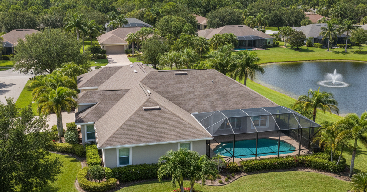
That is where pre-storm drone roof documentation fits. A well-planned drone inspection creates a dated, organized visual baseline of roof surfaces, flashing, skylights, gutters, drainage paths, pool cages, exterior walls, equipment pads, fencing, and surrounding trees. After a storm, the same angles can be repeated so damage can be compared against a clean reference point. The result is not a substitute for a licensed roof inspection, engineering report, or insurance adjuster. It is a stronger visual record that helps everyone start from facts instead of memory.
Why pre-storm documentation matters before June 1
Most property owners think about documentation after a storm, when shingles are missing, gutters are twisted, and water has already entered the structure. That is late. After a hurricane, the condition of the property may be mixed with emergency repairs, debris removal, tarping, standing water, and access restrictions. It becomes harder to separate old wear from new damage, and harder to prove what the property looked like before the event.
Florida's Department of Financial Services tells consumers to report storm damage quickly and to take photos or video to document damage for the company adjuster [3]. It also recommends documenting damage and repairs with receipts, photos, or video after the storm [3]. Those are post-loss steps. Pre-storm documentation complements them by adding the missing baseline: what the same roof planes, roof penetrations, vents, soffits, fascia, exterior walls, and site features looked like before the weather event.
FEMA's hurricane guidance also emphasizes preparing the property before hurricane season and notes that much hurricane-related property damage happens after wind breaks windows, doors, or roof openings and rain enters the building [4]. A roof that already has lifted shingles, cracked tiles, exposed fasteners, ponding water, blocked gutters, weak tree limbs, or aging sealant around penetrations is not just an insurance concern. It is a water intrusion concern. A drone survey can flag visible issues that deserve closer review before the forecast gets serious.
The goal is simple: create a clean, time-stamped visual file before conditions change. When the weather is calm, the property is accessible, and the roof is dry, the documentation is clearer, safer, and more useful.
What a drone roof documentation package should capture
A useful pre-storm drone package is not a random set of aerial photos. It should be repeatable, organized, and focused on the parts of the property that storms tend to exploit.
1. Overall roof condition. The package should include high-resolution roof-plane images from multiple angles, enough to show the full slope, ridges, valleys, eaves, transitions, and roof edges. For tile roofs, the imagery should make cracked, displaced, or missing tiles easier to spot. For shingle roofs, it should capture visible lifting, granule loss patterns, patching, exposed underlayment, or uneven wear. For flat or low-slope commercial roofs, it should document ponding areas, roof drains, scuppers, seams, penetrations, and rooftop equipment.
2. Penetrations and weak points. Roof failures often begin around details: vent stacks, skylights, chimneys, satellite mounts, solar attachments, HVAC curbs, flashing, valley intersections, and edge metal. The documentation should include closer aerial angles of these details without creating unsafe flight paths or violating privacy boundaries.
3. Drainage and surrounding site conditions. Gutters, downspouts, swales, retention areas, clogged drains, nearby trees, overhanging limbs, loose yard structures, fences, screen enclosures, docks, and exterior equipment can all become part of the storm story. A wider aerial pass helps show the relationship between the building and its surroundings. For property managers and association boards, that context can be as useful as the roof photos themselves.
4. Access points and exterior envelope. Garage doors, windows, exterior doors, soffits, fascia, balconies, railings, attached structures, and pool cages should be included when relevant. FEMA advises property owners to prepare homes against wind and water entry before hurricane season [4]. Visual documentation helps owners identify which exterior areas deserve attention before a watch or warning compresses the timeline.
5. Repeatable flight angles. The most valuable package is one that can be repeated after a storm. That means capturing consistent north, south, east, west, oblique, and top-down views where airspace and site conditions allow. If post-storm imagery is captured from similar angles, the comparison becomes more useful for owners, contractors, property managers, and insurance conversations.
Why drones are often better than ladder-only documentation
A ladder can show one edge of a roof. A drone can show the roof as a system. That difference matters in Florida, where a single property may include multiple roof pitches, detached structures, pool enclosures, lanais, solar equipment, tree coverage, and drainage features that are difficult to understand from the ground.
Drone documentation has three practical advantages.
First, it reduces the need for unnecessary roof access during the documentation phase. Not every condition requires someone to step onto tile, metal, or aging shingles just to understand the visible baseline. If the drone imagery reveals a concern, a licensed roofer, inspector, engineer, or other qualified professional can perform the hands-on assessment. The drone does not replace that expert; it helps route attention to the right place.
Second, it captures context. Storm damage is rarely isolated to one shingle. Water intrusion can relate to drainage paths, clogged gutters, tree impact, nearby structures, roof penetrations, flashing details, or wind-driven debris. Aerial imagery makes those relationships easier to explain because the whole site is visible in one record.
Third, it supports faster comparison after the event. The Florida Department of Financial Services advises policyholders to provide photos or video of damage and to keep records for the claims process [3]. If a property already has a pre-storm image set, the post-storm documentation can be organized by matching viewpoints: before ridge view, after ridge view; before pool cage, after pool cage; before southwest roof plane, after southwest roof plane. That structure saves time when people are already under pressure.
Compliance matters: use a professional drone operator
Pre-storm roof documentation is commercial work. It should be performed by a qualified drone operator who understands FAA rules, local airspace, privacy limits, safe launch points, property boundaries, and weather constraints.
The FAA says commercial small drone operations generally follow Part 107 rules for drones under 55 pounds [5]. The FAA also notes that Part 107 operators may fly at night, over people, and over moving vehicles without a waiver only when the operation meets the requirements of the relevant rule, and that controlled airspace still requires airspace authorization for night operations under 400 feet [5]. That matters for real estate and property documentation because many Florida properties sit near airports, heliports, hospitals, coastal corridors, and busy roads.
Remote ID also matters. The FAA's Remote ID rules require registered drones to broadcast identification and location information unless an exception applies [6]. For property owners, this is one reason to hire a professional rather than asking an unqualified hobby pilot to "grab a few roof shots." The cheapest flight can become expensive if it creates privacy, safety, access, or compliance problems.
A professional operator should be able to explain the scope, limitations, and deliverables before flying. For example, the final package may include a gallery of edited reference photos, raw high-resolution images when requested, an annotated contact sheet, short overview video clips, and a post-storm comparison option. It should not promise to determine coverage, assign causation, or replace licensed inspections. Those are different professional roles.
Who should schedule this before hurricane season?
Real estate agents. Active listings are vulnerable during hurricane season. A pre-storm visual package helps agents document listing condition, communicate with sellers, and preserve marketing continuity if the property is affected. For vacant, seasonal, or out-of-area seller properties, the value is even higher because no one may be checking the roof daily.
Property managers and landlords. Rental homes, small multifamily assets, and commercial properties need organized records across multiple addresses. Drone documentation can standardize the view of each property before storm season, making it easier to prioritize repairs and communicate with owners after an event.
Builders and developers. Active jobsites have open materials, partial roof systems, equipment, temporary drainage, and changing site conditions. Pre-storm documentation helps teams show what was complete, what was staged, what was exposed, and what changed after a storm. It also supports progress reporting when stakeholders cannot get to the site immediately.
Condo associations and HOAs. Associations often need to coordinate roof, exterior, drainage, common-area, and amenity documentation. A drone package can capture clubhouse roofs, pool areas, parking lots, perimeter fencing, stormwater features, signage, and common structures in one organized visual record.
Owners of high-value homes. Luxury properties often have complex rooflines, solar installations, pool enclosures, docks, outdoor kitchens, guest houses, landscape lighting, and waterfront features. Ground photos rarely capture the full risk picture. Aerial documentation gives owners a cleaner baseline before damage, repair crews, or debris removal change the scene.
How to build a practical pre-storm documentation schedule
The best schedule is simple enough to repeat. A practical Florida plan has three stages.
Stage 1: preseason baseline, May to early June. Capture the full property before the season is active. This creates the clean reference set while access is easy and contractors still have time to address visible concerns.
Stage 2: pre-landfall update when a credible threat exists. If a storm track puts the property at risk and conditions are still safe and legal for flight, capture a short update after temporary preparations are complete. This may include shutters, secured outdoor items, cleared drains, moved equipment, and site condition immediately before impact. Flights should never be attempted in unsafe winds, rain, emergency restrictions, or restricted airspace.
Stage 3: post-storm comparison. After the storm, when it is safe and lawful to fly, capture the same core angles and details. Florida DFS recommends documenting damage with photos or video and filing claims quickly [3]. Matching post-storm imagery to a preseason baseline gives owners and professionals a more organized record for decisions.
The key is to avoid waiting until the county is already in emergency mode. Once storm watches, evacuations, fuel shortages, road closures, rain bands, and contractor backlogs begin, the window for clean documentation gets smaller fast.
What Property HDR provides
Property HDR can prepare pre-storm drone roof and exterior documentation packages for Florida real estate listings, rental properties, construction sites, associations, and private owners. The service is designed to be practical: professional aerial imagery, organized exterior coverage, repeatable viewpoints, and delivery formats that owners, agents, contractors, and property managers can actually use.
Typical deliverables can include high-resolution roof and exterior photos, aerial overview images, short video clips, a structured file gallery, and optional post-storm comparison coverage. For construction sites or larger properties, documentation can be paired with progress media, site overview photography, and photogrammetry workflows when the project requires measurable context.
Property HDR does not replace licensed roofers, engineers, adjusters, or inspectors. The purpose is to create a strong visual record before and after weather events so those professionals and stakeholders can work from better information.
Conclusion: do the boring work before the exciting weather
Hurricane season preparation is not just plywood, batteries, and bottled water. For Florida property owners and professionals, it is also documentation. The calm weeks before the season are the right time to capture the roof, exterior, drainage, and site condition in a way that can be compared later.
NOAA's 2026 outlook may point to a less active Atlantic season, but Florida does not need a busy season to have a damaging storm. A pre-storm drone roof documentation package gives owners and professionals a clearer baseline, better post-storm comparison, and a more organized record when decisions have to be made quickly.
Need a pre-storm roof and exterior documentation package before hurricane season accelerates? Request a Quote from Property HDR.
Sources
Associated Press. (2026, May 21). Atlantic hurricane season forecast to be milder than normal thanks to El Nino.
National Hurricane Center. (2026). Hurricane Season Dates and Tropical Weather Outlook.
Florida Department of Financial Services. (2026). Hurricane Recovery Resources and Storm Claims Guidance.
Federal Emergency Management Agency. (2022). Tips to Prepare Your Home for Hurricane Season.
Federal Aviation Administration. (2026). Certificated Remote Pilots including Commercial Operators.
Federal Aviation Administration. (2026). Remote Identification of Drones.