Why Aerial Photogrammetry Is Becoming Essential for Florida Property Surveys
Florida property decisions are becoming more data-heavy. Agents, developers, builders, lenders, and property owners are no longer relying on ground photos, parcel maps, and a few inspection notes to understand a site. They need visual context, elevation awareness, access documentation, and repeatable records that can be reviewed by teams who may never walk the property in person.
That is where aerial photogrammetry fits. It does not replace a licensed boundary survey, and it should not be marketed as a substitute for legal survey work. But for many real estate, development, construction, and inspection workflows, drone-based photogrammetry gives stakeholders a fast, visual, measurable way to understand a property before decisions become expensive.
The timing matters. Florida’s 2026 housing market is active but more selective. Florida Realtors reported that March 2026 existing single-family closed sales rose 5.9% year over year, condo-townhouse closed sales rose 12%, and inventory remained materially different by property type, with 4.8 months’ supply for single-family homes and 9.1 months’ supply for condo-townhouses [1]. In that kind of market, buyers and investors compare properties more carefully, developers need tighter pre-construction documentation, and sellers need better ways to explain land, access, drainage, improvements, and surrounding context.
Aerial photogrammetry is becoming essential not because drones are fashionable, but because Florida property decisions often depend on questions that ordinary listing photos cannot answer.
What aerial photogrammetry actually provides
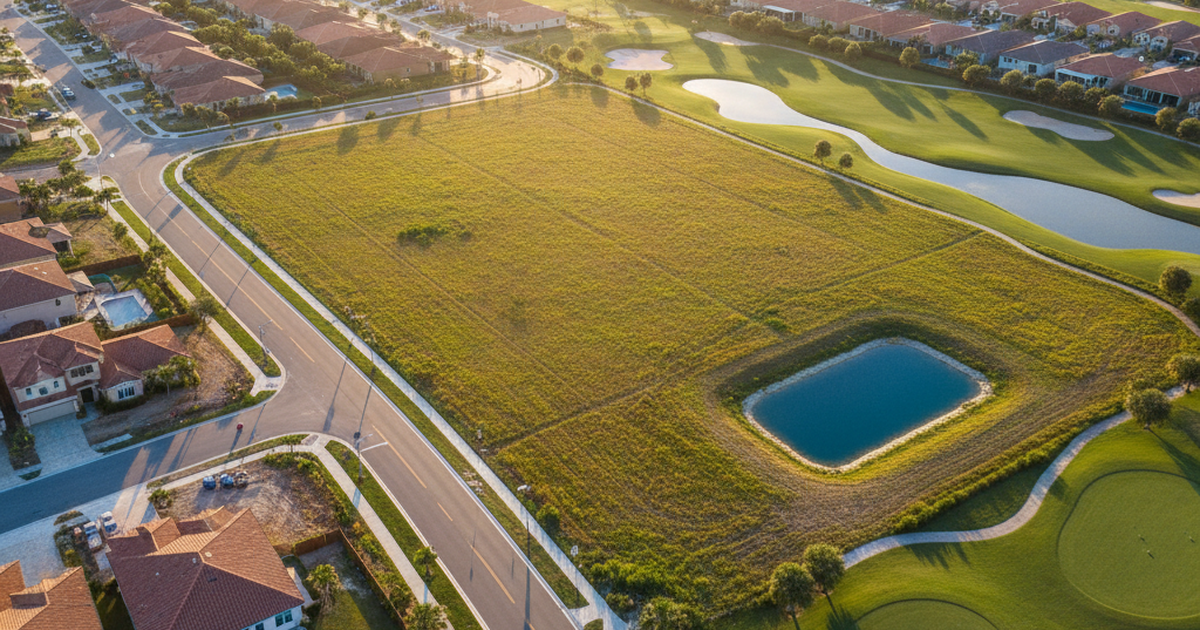
Photogrammetry is the process of capturing overlapping images and using software to reconstruct measurable maps, models, and surface information from those images. In a property workflow, a drone flies a structured path over the site, captures a sequence of high-overlap photos, and those images are processed into deliverables such as an orthomosaic map, 3D model, digital surface model, elevation visualization, or progress comparison.
The key difference between a normal drone photo and a photogrammetry deliverable is repeatability. Aerial marketing photos show what a property looks like. Photogrammetry helps document where things are, how the site is shaped, and how conditions compare over time.
For Florida real estate and construction teams, that difference is practical. A developer reviewing a parcel can see vegetation, site access, drainage patterns, adjacent roads, retention areas, and nearby development context. A builder can compare current conditions to prior flights. A broker can explain a large commercial parcel more clearly to an out-of-state buyer. A property owner can document conditions before grading, clearing, repair work, or insurance-related changes.
None of this means a drone map is automatically a certified survey. It means the project team gets a richer visual and spatial record before deciding whether to order additional engineering, surveying, legal, or environmental work.
Why Florida properties create a strong use case
Florida has a combination of conditions that make aerial documentation especially useful: large master-planned communities, rapid subdivision growth, mixed residential and commercial development, flood-sensitive areas, storm exposure, wetlands, retention ponds, and a heavy volume of out-of-area buyers and investors.
FEMA’s own flood mapping guidance is a reminder that flood risk is not limited to waterfront parcels. FEMA notes that heavy rains, poor drainage, and nearby construction projects can create flood risk, and that flood maps are used by communities to identify areas with higher likelihood of flooding [2]. FEMA also defines high-risk areas as places with a 1% or greater annual chance of flooding, which translates to at least a one-in-four chance of flooding during a 30-year mortgage [2].
That context matters for property media. Aerial photogrammetry will not determine flood insurance requirements by itself. It will not replace FEMA maps, elevation certificates, civil engineering, or municipal review. But it can create a high-quality visual record of site conditions that helps teams ask better questions earlier: Where does water appear to drain? How close are retention features? Is the site flat or visibly varied? Has nearby construction changed access, drainage, or surrounding grade? Is the parcel easy to understand from ground-level images alone?
Florida’s state-level flood and sea-level rise assessments also show why property location and exposure require careful documentation. The Florida Office of Economic and Demographic Research’s 2025 Annual Assessment includes county-level taxable value exposure in high-impact coastal areas, with several coastal counties showing large shares of taxable value in exposure zones [3]. The practical lesson for real estate and development teams is not that every property is high-risk. The lesson is that location-specific documentation matters, and aerial context can make those conversations more concrete.
Where photogrammetry fits in the property survey workflow
The safest way to use aerial photogrammetry is to treat it as a decision-support layer, not a legal boundary product. A licensed land surveyor is still required for boundary surveys, ALTA/NSPS surveys, signed and sealed deliverables, easement questions, legal descriptions, and official survey records. A drone pilot should never imply that an orthomosaic replaces that work.
Where photogrammetry shines is before, during, and between those formal survey moments.
Before acquisition or listing: Aerial mapping helps a buyer, seller, broker, or developer understand the parcel visually. This is useful for larger acreage, commercial land, agricultural parcels, infill development, vacant lots, and properties where access or surrounding context affects value.
Before construction: A pre-construction drone map documents site conditions before clearing, grading, staging, or material delivery. That record can become valuable when teams need to compare what changed later.
During construction: Repeated flights can create a progress archive. Instead of relying on scattered phone photos, stakeholders can review consistent overhead documentation tied to dates, locations, and phases.
After storms or site events: Florida properties are exposed to hurricanes, heavy rain, and rapid weather changes. Aerial documentation can help capture visible conditions after an event, especially for roofs, drainage areas, access roads, fencing, staging zones, and exterior improvements. Any insurance or engineering conclusion still belongs to the qualified professional, but the visual record is often useful.
For marketing and investor communication: A processed orthomosaic or 3D model can help explain a property more clearly than still images alone. For developers, that matters when presenting land, site progress, future phases, or surrounding growth to partners who are not local.
Accuracy is improving, but expectations must be managed
Accuracy is the topic that separates responsible drone providers from careless ones. Photogrammetry can be highly useful, but the quality of the output depends on flight planning, overlap, camera quality, altitude, lighting, ground control, processing, and site conditions.
Recent research supports the direction of the technology. A 2025 open-access paper in Automation in Construction studied land surveying with UAV photogrammetry and LiDAR for building planning. The authors proposed a Digital Feature Model that fused photogrammetry and LiDAR data. In their built-environment case study, the fused method achieved a vertical RMSE of 0.075 meters, compared with 0.209 meters for the photogrammetry model and 0.130 meters for the LiDAR model [4]. That result is important because it shows both the promise and the limitation: sensor fusion can improve reliability, while standalone outputs still vary by method and conditions.
For practical property work, the message is clear. Drone photogrammetry can be precise enough for many planning, visualization, documentation, and measurement-support tasks, but it must be scoped correctly. If a client needs legal boundaries, certified elevations, engineering tolerances, or signed survey deliverables, the project should involve a licensed surveyor or engineer. If the client needs visual site intelligence, construction progress documentation, marketing context, or a repeatable property record, photogrammetry can be an efficient tool.
Photogrammetry, LiDAR, and standard aerial media are not the same service
Property teams sometimes use “drone survey,” “mapping,” “3D model,” and “aerial photos” as if they mean the same thing. They do not.
Standard aerial photography is best for marketing, listing presentation, neighborhood context, and visual storytelling. It is fast and useful, but it is not designed as a measurable map.
Photogrammetry uses overlapping images to build maps and models. It is strong for open sites, visible surfaces, orthomosaics, construction progress, 3D visualization, and color-rich documentation.
LiDAR uses laser pulses to measure surfaces and can perform better where vegetation, low texture, or terrain complexity limits image-based reconstruction. It is often better suited for wooded sites, dense terrain, and certain engineering-grade workflows.
Hybrid workflows combine data sources. The 2025 Automation in Construction study is a good example of why that matters: the fused model outperformed the individual photogrammetry and LiDAR models in vertical RMSE [4].
For Florida properties, the right tool depends on the site. An open development parcel may be an excellent candidate for photogrammetry. A heavily wooded parcel may require LiDAR or a licensed survey team using multiple methods. A residential listing may only need polished aerial media. A construction project may benefit from scheduled mapping flights, progress photos, and periodic model updates.
Compliance is part of the deliverable
Commercial drone work in the United States is regulated. The FAA states that drones under 55 pounds may be flown for work or business by following Part 107 rules, and operators are responsible for understanding where it is and is not safe to fly [5]. The FAA also notes that Part 107 operations may include night operations and operations over people or moving vehicles only when the rule’s requirements are met, and that airspace authorization is still required for night operations in controlled airspace under 400 feet [5].
For real estate and construction clients, this is more than a legal footnote. Hiring an unqualified drone operator can create scheduling risk, insurance risk, and liability concerns. A professional workflow should include airspace checks, equipment readiness, appropriate flight planning, weather review, safe launch and recovery procedures, and clarity about what the deliverable is — and is not.
Compliance also affects data quality. A rushed flight, poor overlap, bad lighting, or unsafe altitude selection can produce a model that looks impressive but is not reliable. The best provider is not simply the one with a drone. It is the one who understands media, mapping, regulation, site conditions, and the client’s business objective.
How Florida agents, developers, and builders can use it now
For real estate agents, aerial photogrammetry is most useful when a property’s value depends on land, layout, context, access, water, or future development potential. Large lots, waterfront-adjacent parcels, rural properties, commercial land, redevelopment sites, and investor listings can all benefit from clearer aerial documentation.
For developers, the value is in reducing ambiguity. A pre-acquisition or pre-construction map gives the team a shared reference. Scheduled flights create a timeline. Orthomosaics and 3D views can help communicate progress to partners, lenders, and stakeholders without requiring everyone to visit the site.
For builders and contractors, repeatable aerial documentation supports progress reporting. It helps show what happened, when it happened, and where it happened. That does not eliminate disputes, but it creates a stronger visual record than disconnected jobsite photos.
For property owners and managers, photogrammetry can document exterior conditions, roofs, drainage areas, fencing, access roads, parking lots, and site improvements. That record becomes especially valuable when repairs, storms, maintenance, or capital improvements are part of the property story.
What to ask before ordering aerial photogrammetry
Before hiring a provider, Florida clients should ask five practical questions:
- What decision will this deliverable support? Marketing, planning, construction documentation, investor presentation, inspection support, or survey coordination?
- Is a licensed surveyor required? If the answer involves legal boundaries, official elevations, easements, or signed deliverables, bring in the proper professional.
- What outputs will be delivered? Orthomosaic, 3D model, annotated photos, progress comparison, video, stills, or a package combining several items?
- What accuracy level is appropriate? Not every project needs survey-grade precision, but every project needs honest expectations.
- How will the data be used later? A one-time map is useful. A repeatable documentation system is often more valuable.
Those questions keep the project grounded. They also prevent a common problem: paying for a deliverable that looks technical but does not answer the client’s real business question.
The bottom line
Aerial photogrammetry is becoming essential for Florida property surveys because the property conversation has changed. Buyers want context. Developers want documentation. Builders want progress visibility. Owners want records. Agents need better ways to explain properties in a selective market. And Florida’s land, water, construction, and weather conditions make aerial context more than a visual upgrade.
The responsible position is simple: drone photogrammetry should complement professional surveying, engineering, inspection, and real estate work — not pretend to replace it. Used correctly, it gives teams a clearer view of the property, a better record of site conditions, and a stronger foundation for decisions.
Property Media Group helps Florida agents, developers, builders, and property owners capture professional aerial media, construction documentation, and photogrammetry-ready imagery for real estate and project communication. If your next listing, land parcel, construction site, or property inspection needs better visual documentation, Request a Quote and we will help define the right package for the job.
Sources
- Florida Realtors. (2026, April 17). Fla.’s Housing Market: Closed & New Pending Sales Up in March, 1Q. https://www.prnewswire.com/news-releases/flas-housing-market-closed--new-pending-sales-up-in-march-1q-302745967.html
- Federal Emergency Management Agency. (n.d.). Flood Maps. https://www.fema.gov/flood-maps
- Florida Office of Economic and Demographic Research. (2025). Annual Assessment of Flooding and Sea Level Rise, Chapter 6. https://edr.state.fl.us/Content/natural-resources/2025_AnnualAssessmentFloodingandSeaLevelRise_Chapter6.pdf
- Automation in Construction. (2025). Land surveying with UAV photogrammetry and LiDAR for optimal building planning. https://www.sciencedirect.com/science/article/pii/S0926580525001323
- Federal Aviation Administration. (n.d.). Certificated Remote Pilots including Commercial Operators. https://www.faa.gov/uas/commercial_operators