The Hidden Cost of Being Blindsided on a Construction Project
Stand in the middle of a 40-story tower job site in downtown Miami and ask the project manager how far along they are. You might get a confident answer: "We're about 73 percent complete." Now fly a drone overhead with RTK positioning, process the imagery through photogrammetry software, and overlay the resulting point cloud against the BIM model. The data will tell you something different. The structural framework sits at 61 percent. Finish work on floors 18 through 24 is lagging. The mechanical shaft on the east core has a framing error that no one caught from the ground. The discrepancy between perceived progress and measured reality is not an exception. It is the industry norm.
Construction progress monitoring is undergoing a fundamental shift. The tools that were once reserved for large infrastructure projects and technically sophisticated general contractors have become accessible to mid-market developers, multifamily builders, and single-project investors. At the center of this transformation is 3D modeling, built from drone-captured photogrammetry or terrestrial laser scanning, and integrated into workflows that were previously dependent on clipboard walks and optimistic field reports.
This article examines how 3D modeling is changing the way developers track, document, and manage construction projects. The data is clear, the use cases are specific, and the ROI is measurable.
What Construction Progress Monitoring Actually Means in 2026
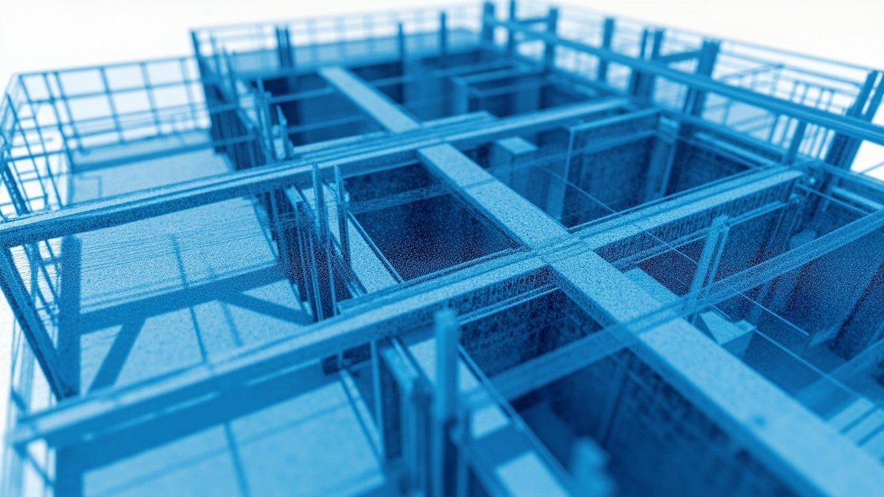
Construction progress monitoring is not a single technology. It is a discipline that encompasses periodic site documentation, comparison of as-built conditions against design intent, and the communication of findings to stakeholders who need to make funding decisions, release draws, or approve change orders. In practice, it draws on four overlapping technology categories: photogrammetry, laser scanning, Building Information Modeling, and digital twin platforms.
Photogrammetry uses overlapping aerial photographs captured by drones to reconstruct three-dimensional geometry of a job site. With RTK (Real-Time Kinematic) or PPK (Post-Processed Kinematic) positioning and properly distributed Ground Control Points, this method achieves horizontal accuracy of 1 to 3 centimeters and vertical accuracy of 2 to 5 centimeters, according to multiple industry studies and manufacturer specifications. Ground Sample Distances of 1 to 3 centimeters per pixel are standard for construction monitoring applications, enabling detection of element-level deviations rather than just overall site impressions.
Laser scanning, once a specialist activity costing tens of thousands of dollars per scan session, has become faster and more affordable. Modern terrestrial LiDAR devices like the Matterport Pro3 capture full spatial scans in approximately 20 seconds per position, producing point clouds that can be registered into comprehensive site models. While still more time-intensive than photogrammetric capture, laser scanning delivers superior accuracy on complex surfaces and interiors where photogrammetric reconstruction may struggle.
BIM models, created in software such as Autodesk Revit, form the design-intent backbone of the monitoring workflow. The value emerges when reality capture data is compared against the BIM model at each project milestone, producing quantifiable deviation reports that go far beyond a photographer's annotated still images.
The Rework Problem: Why Progress Visibility Directly Affects the Bottom Line
To understand why progress monitoring matters financially, start with the rework problem. The Construction Industry Institute reported in multiple studies that rework costs range from 2 to 20 percent of total project cost, with most peer-reviewed studies placing the average between 5 and 10 percent. A 2024 study by PlanRadar put the global average at 7.9 percent. The United States construction industry loses an estimated $177.5 billion annually in labor costs driven by avoidable rework, miscommunication, and search for project data, according to research by Autodesk and FMI.
The mechanism is direct. When a framing error goes undetected through multiple finish stages, correcting it requires demo, re-framing, re-inspection, and re-finishing. Each stage carries material costs, labor costs, schedule impacts, and indirect costs from disruption to downstream trades. Industry research cited by the Navigant Construction Forum found that the indirect cost of rework runs approximately 80 percent above the direct cost of the correction itself. A $50,000 framing fix, in other words, typically costs $90,000 when schedule disruption, labor re-mobilization, and downstream delays are included.
Progress monitoring powered by 3D modeling catches these deviations early. When a point cloud scan of floor 20 is compared against the BIM model at the same stage, deviations become numerically quantifiable. A column that should be at elevation 62.5 feet but sits at 62.3 feet is a 5-centimeter error. That error, if caught before concrete pour on the slab above, costs almost nothing to correct. The same error, discovered after the slab has been poured and the mechanical rough-in has proceeded through that level, may cost tens of thousands of dollars and weeks of schedule delay.
The Measurable ROI: What the Data Shows
The case for 3D modeling in construction progress monitoring is not theoretical. It is supported by published project data from multiple sources.
Wesbuilt Construction, a New York-based contractor, implemented bi-weekly 3D scans to track progress and maintain as-built records across complex commercial builds. The results: 61 percent reduction in document errors and omissions, 36 percent reduction in rework hours, 22 percent faster project completion, and 17 percent fewer claims and litigation events. These are not estimates. They are project outcomes reported through the contractor's quality management system.
The State of Michigan Department of Transportation calculated a net benefit of over $18 million from its implementation of as-delivered 3D models for road construction between 2012 and 2016. The ROI on those models was 32 percent, meaning every dollar invested returned 32 cents in reduced change orders, lower bid prices, and improved constructibility. Contractors working with MDOT's models reported saving 25 to 50 percent of the time typically required to create their own modeling and machine control data, translating to approximately $750 in savings per lane mile on earthwork.
In commercial office construction, a developer using drone-based progress monitoring on a 20-story renovation reduced inspection time by over 60 percent and labor costs by nearly 30 percent, while generating 3D models that enabled early detection of structural issues. The overall improvement in project ROI was 25 percent. A separate study of commercial office projects documented through drone photogrammetry found that traditional inspection methods consistently overestimated structural completion by 10 to 15 percentage points compared to scan data, a discrepancy that can represent millions of dollars in delayed detection on large projects.
For construction loan monitoring, the value is tangible for a different set of reasons. Lenders releasing draws against a percentage-of-completion schedule need defensible, objective data. A drone flight capturing a site on a Monday morning produces imagery that can be processed into an orthomosaic and compared against the prior month's capture by Tuesday. The visual difference, quantified in area and volume, gives the lender's inspector a measurement-grade basis for approving or questioning a draw request, rather than relying on a site manager's attestation.
How the Technology Works in Practice
A typical progress monitoring workflow using drone photogrammetry follows a consistent sequence. The drone is programmed to fly a predefined grid pattern at a consistent altitude, typically between 100 and 200 feet for a construction site of 5 to 50 acres, capturing images with 75 to 85 percent overlap. RTK positioning or ground control points anchor the imagery to real-world coordinates. After landing, the images are processed through software such as Pix4D, DJI Terra, or DroneDeploy to produce an orthomosaic, a digital surface model, a 3D point cloud, and in many cases a textured mesh.
That output is then compared against the current BIM model. Discrepancies are color-coded by severity and trade, and flagged for field investigation. The process takes 24 to 72 hours from flight to actionable report, depending on site size and processing hardware. Some platforms, including DroneDeploy and OpenSpace, offer weekly or bi-weekly monitoring subscriptions that integrate directly with project management platforms such as Procore and Autodesk Construction Cloud, enabling the comparison data to appear in the same workspace where RFIs, change orders, and submittals are managed.
The level of detail achievable with current hardware is sufficient for element-level quality control. A 3 centimeter-per-pixel GSD enables identification of missing flashing, displaced rebar chairs, and incomplete waterproofing at the membrane stage. On a multifamily project with 300 units, catching a waterproofing defect before the facade closes in is the difference between a $5,000 touch-up and a $400,000 facade removal and replacement.
The Digital Twin as Long-Term Asset
The value of capturing progress data in 3D extends beyond the construction phase. A comprehensive reality capture record becomes the foundation for a digital twin of the completed building. Digital twins, according to research published by Matterport and construction technology firms, serve as living documentation that evolves through the building's operational life.
Facility managers who receive a digital twin at project handover gain the ability to locate building assets spatially, plan preventive maintenance based on actual installation conditions, reduce energy waste through accurate as-built documentation, and simulate renovation scenarios without invasive investigation. Research from the BIM and digital twin space indicates that facility management teams using digital twin records see longer asset lifespans, lower maintenance costs, and measurably better operational efficiency than those managing buildings from paper as-built drawings alone.
For developers who maintain portfolios, the compounding value is significant. A digital twin created at project closeout becomes a marketing asset for future tenant buildouts, a due diligence resource for property sales, and an insurance documentation source in the event of damage claims. The cost of capturing it during construction is essentially marginal since the site is already being documented.
What Florida Developers in Particular Should Know
Florida's construction market presents specific conditions that make progress monitoring technology particularly valuable. The state's combination of high humidity, hurricane code requirements, and aggressive development timelines means that moisture intrusion, structural framing, and waterproofing details carry outsized consequences. A two-inch error in the waterproofing membrane at the fenestration interface is a latent defect that may not manifest until the first major storm event, at which point the legal and remediation exposure is severe.
Florida's building inspection requirements have also tightened in response to the Surfside condo collapse, with SB-4D mandating milestone inspections for buildings above three stories. Construction progress monitoring documentation creates the contemporaneous record that demonstrates compliance and due diligence, protecting developers and property owners from the post-occurrence scrutiny that followed the 2021 collapse.
The competitive dynamics of Florida multifamily development add a schedule dimension. Projects in high-absorption submarkets such as Tampa, Orlando, and South Florida conventional or LIHTC multifamily face financing structures where completion delays directly affect debt service and investor returns. Any tool that compresses the construction schedule by catching and correcting deviations early is worth multiples of its cost in that environment.
The Practical Barriers and How to Address Them
It would be incomplete to present this technology as a simple purchase order. Several practical barriers affect adoption. The first is pilot availability and FAA compliance. Commercial drone operations in the United States require an FAA Part 107 certified pilot, current weather minimums, and in some Florida municipalities, local permits for flight over populated areas. Developers who do not have an in-house drone program need to engage a licensed commercial operator, which adds cost and coordination complexity.
The second barrier is software integration. The output from a photogrammetry platform is only as valuable as the workflow that consumes it. A point cloud that sits in a software folder without being compared against the BIM model, distributed to the relevant subcontractors, and incorporated into the RFI process generates no value. The technology purchase decision should include an honest assessment of the team's ability to operationalize the data.
The third barrier is frequency. A single drone flight captures a moment in time. Construction is dynamic. Monthly flights are better than quarterly flights. Weekly flights are better than monthly. The practical constraint is cost and scheduling. This is where the calculation shifts: the cost of a weekly drone flight, at current commercial rates, is typically 0.1 to 0.3 percent of a mid-size project's total construction cost. The value of catching one significant deviation per month that would otherwise result in a change order is almost always a positive return on that investment.
Making the Decision
The case for incorporating 3D modeling into construction progress monitoring is not a prediction about the future of the industry. It is a description of the current state of practice among developers and contractors who are consistently delivering projects ahead of schedule and under budget compared to those relying on traditional methods.
The entry point is accessible. A developer starting a 150-unit multifamily project in Central Florida can engage a commercial drone operator for an initial baseline scan, monthly progress flights, and a final as-built capture for approximately the cost of two to three days of a site inspector's time. The data produced is objective, shareable, and defensible. Lenders appreciate it. Equity investors expect it. And when the completed building is turned over to a property manager, the digital twin that results from the process is an asset that continues to generate value for the life of the building.
The developers who are not using these tools are not making a conscious choice to accept higher rework costs and schedule risk. They are making an passive choice driven by inertia and lack of information. The technology is available, the cost is manageable, and the data is actionable. The question is not whether 3D modeling will become standard in construction progress monitoring. It is how quickly a given developer or project will adopt it.
Property Media Group provides drone-based construction progress monitoring, photogrammetry, and 3D modeling services for developers, lenders, and general contractors throughout Florida. To discuss your next project, request a quote.